

From Satellite Alerts to Action: Community-Led Forest Monitoring Reveals Escalating Deforestation in Watsa Territory, DRC

Watsa, Haut-Uele Province, Democratic Republic of Congo
Across the forests of Watsa Territory in northeastern Democratic Republic of Congo, deforestation is accelerating under growing pressure from artisanal mining, semi-industrial mining, charcoal production, and agricultural expansion. As part of the Congo Basin, these forests are globally significant for biodiversity conservation, climate regulation, and the livelihoods of local communities.
Recent Global Forest Watch (GFW) monitoring highlights the urgency of the situation. During the week of 24 June 2026 alone, GFW detected 1,677 forest disturbance alerts in Watsa Territory, affecting approximately 20.61 hectares of forest cover. While these alerts represent only one week of monitoring, they reflect a much larger and continuing pattern of forest degradation across the territory.
To strengthen local responses, Alphome Community Farms, with support from the World Resources Institute (WRI)through the Global Forest Watch Small Grants Fund, is combining satellite monitoring with community-based field verification to generate reliable evidence for forest conservation and advocacy.
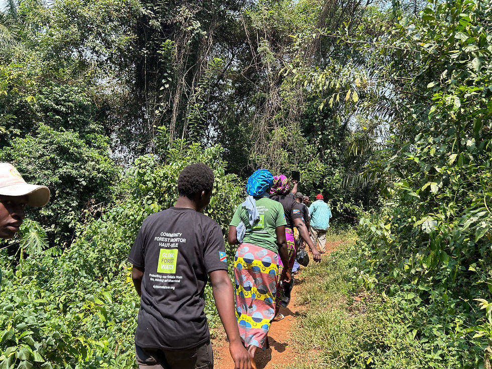
Between January and June 2026, our analysis identified more than 5,000 satellite deforestation alerts across Watsa Territory. Using Global Forest Watch and the Forest Watcher mobile application, trained community monitors verified these alerts through systematic field investigations.
Turning Satellite Data into Verified Evidence
Remote sensing alone cannot explain what is happening on the ground. That is why Alphome Community Farms combines satellite monitoring with field verification.
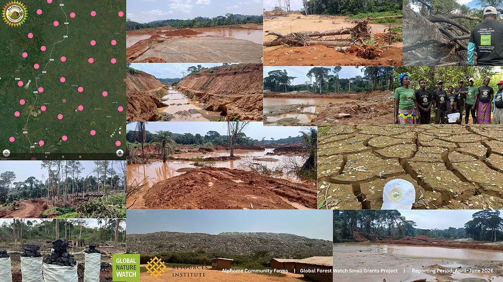
Between October 2025 and June 2026, our team carried out 37 field verification missions across Watsa and Faradje Territories. These missions confirmed that extensive forest disturbance is primarily linked to artisanal mining, charcoal production, and agricultural expansion, while also documenting expanding forest clearance associated with semi-industrial mining operations in several parts of Watsa Territory.
Community monitors collected GPS coordinates, photographs, and field observations, transforming satellite alerts into verified evidence that can support conservation planning, environmental advocacy, and stronger forest governance.
Mapping Forest Loss Across Watsa Territory
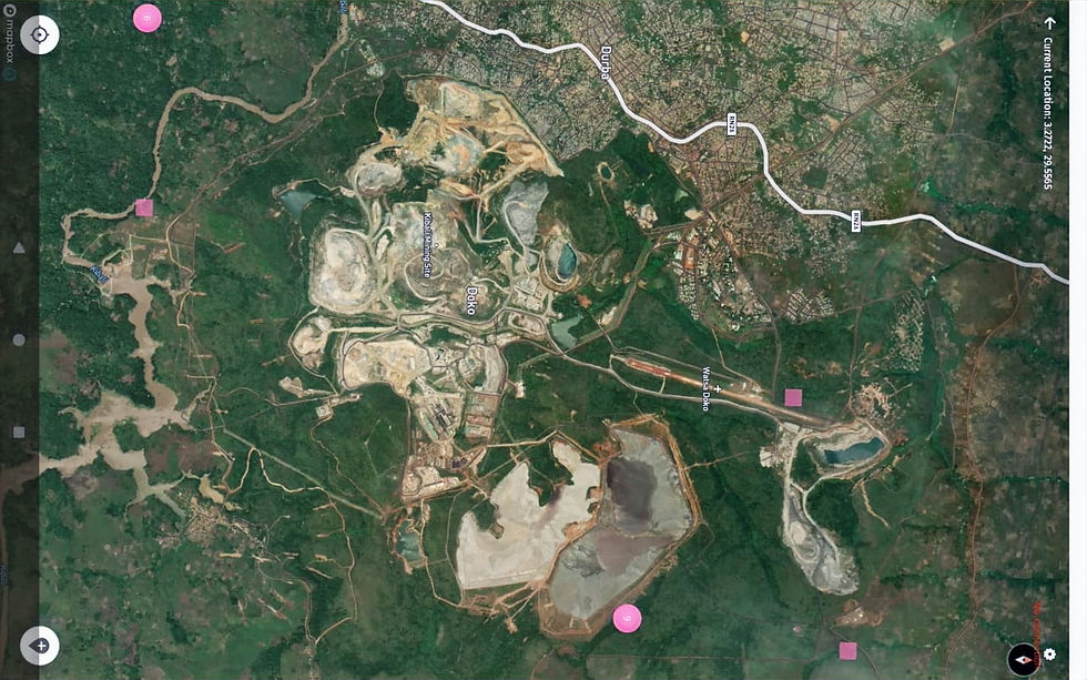
One of the project's major achievements is the production of a comprehensive map identifying the most affected areas across Watsa Territory.
The analysis identified 18 major deforestation hotspots concentrated around the Kibali Gold Mine corridor, where mining-related activities are placing increasing pressure on surrounding forest landscapes.
Among the documented hotspots were:
Kose-Kia, Mai, Agubu, Bwandi, Obeledi, Giro and Beleu: 2,437 satellite alerts
Djamoli and Tumu: 1,150 alerts
Sesenge and Dubele: 684 alerts
Sirigi-Moke: 623 alerts
Mayka: 563 alerts
Kitango (Obugu): 328 alerts
Awago and Tavudri: 256 alerts
Maituru: 243 alerts
Nzoro: 214 alerts
Dopaie: 182 alerts
Serika: 149 alerts
Ndolomo: 132 alerts
Bavungula: 112 alerts
Gese: 113 alerts
Kalimva: 23 alerts
Gatanga: 16 alerts
Doko: 12 alerts
Together, these hotspots account for thousands of deforestation alerts detected during the monitoring period, illustrating the concentration of forest disturbance in and around active mining landscapes.
Forests Are Being Cleared at an Alarming Scale
Field verification revealed that, in several monitored locations, between 20 and 150 hectares of forest had been cleared per site.
Our teams documented forest loss associated with artisanal mining, widespread charcoal production, agricultural expansion, and semi-industrial mining operations, including sites operated by Chinese-owned companies in parts of Watsa Territory. These observations indicate that forest disturbance is occurring over increasingly large areas, threatening biodiversity, ecosystem services, and community livelihoods.

Why This Matters
The forests of Haut-Uele form part of the globally significant Congo Basin, the world's second-largest tropical rainforest. Protecting these forests is essential for biodiversity conservation, climate regulation, water security, and the livelihoods of local communities.
The evidence gathered by this project demonstrates the value of combining satellite monitoring with community-led field verification. We want these reliable data help government institutions, mining stakeholders, civil society organizations, and conservation partners better understand where forest loss is occurring and support more informed decision-making.
However, the scale of forest disturbance documented during this monitoring period also highlights the need for stronger environmental oversight, improved enforcement of environmental regulations, greater transparency in mining activities, and increased investment in community-based forest monitoring.

A Community-Led Commitment to Forest Protection
Alphome Community Farms remains committed to ensuring that local communities are not only witnesses to environmental change but active partners in protecting the forests on which they depend.
With continued support from the World Resources Institute (WRI) and the Global Forest Watch Small Grants Fund, we will continue monitoring forest change, verifying satellite alerts, documenting evidence, and advocating for sustainable management of the forests of Watsa and the wider Congo Basin.

Together, data, communities, and accountability can help safeguard one of Africa's most important forest landscapes for future generations.


Comments